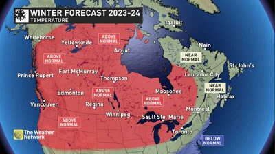
El Niño has a reputation for bringing mild winters to most of Canada. Strong El Niño conditions have developed in the Pacific Ocean, so can we expect a mild winter across Canada again this year? To answer that question, The Weather Network has released its winter forecast for the months of December, January and February.

The winter forecast does feature a mild start to the season, with a delay in the arrival of consistent cold weather for most Canadians. However, January and February could bring a dramatic pattern change to parts of Canada that would challenge our perception of El Niño winters.
“The current El Niño event and ocean water temperatures across the Pacific Ocean are giving us a pattern that is unlike anything that we have ever seen before,” said Chris Scott, Chief Meteorologist at The Weather Network. “Therefore, we believe that the upcoming season will deliver some curveballs that will set this winter apart from typical El Niño winters. While mild temperatures should continue to dominate across western Canada, it appears to be a different story for the eastern half of Canada where winter is expected to make more than just a token appearance.”
What is El Niño?
El Niño is associated with warmer-than-normal ocean water temperatures in the tropical region of the Pacific Ocean to the west of South America. This has an impact on the global jet stream pattern.
Here’s a more detailed look at what we can expect across the country during the upcoming winter season:
British Columbia
A typical El Niño is expected across the province with mild Pacific air dominating through most of the season and fewer-than-normal arctic outbreaks. A drier-than-normal winter is also expected across most of the province. The south coast region should see below normal snowfall and more sunshine than is typical during winter. However, precipitation totals should still end up near normal due to a few periods when the storm track will shift north into the region and bring Pineapple Express events with a risk for excessive rainfall.
Prairies
A mild winter is expected across the region, especially across Alberta and into Saskatchewan, and a few spots which are accustomed to seeing a white Christmas are at risk to miss out this year. Below-normal snowfall is also expected across western and central parts of the region. However, January and February should still deliver periods of more traditional winter weather, especially across Manitoba where snow totals are expected to be near normal.
Ontario and Quebec
A mild start to winter is expected, with less snow than normal during the weeks leading up to the holidays. However, a pattern change is expected as we get deeper into the season with periods of much colder weather expected. Below-normal snowfall is expected for most of the region as the storm track will often be well south of the region. However, if the storm track shifts far enough north at times, then southern parts of the region will still see near-normal snow totals.
Atlantic Canada
A changeable, but overall near-normal, winter is expected across the region. Periods of mild weather should be offset by periods of cold weather, resulting in near-normal temperatures overall. The active storm track across the southern and eastern U.S. will take many storms out to sea rather directly into Atlantic Canada. However, enough moisture-laden systems are expected to impact the region to bring near or slightly above normal snow and rain totals to the region.
Northern Canada
Milder-than-normal temperatures are expected across most of the region, but a cold start to winter across Alaska should spread into the Yukon at times. As we get deeper into winter, we are watching the potential for a piece of the polar vortex to sit over northern Hudson Bay and Baffin Island, which would bring a period of colder than normal temperatures to those areas.
Keep in mind that winter brings rapidly changing weather and dangerous travel conditions throughout Canada. Canadians should pay close attention to the daily forecast and be prepared for changeable weather by visiting theweathernetwork.comor by downloading The Weather Network App and creating an account for personalized and up-to-the minute forecasts.
| The Weather Network: Winter 2023-24 Forecast | ||
| Region | Temperature Outlook | Precipitation Outlook |
| British Columbia | Above normal | Below normal; Near normal south coast and far north |
| Alberta | Above normal | Below normal |
| Saskatchewan | Above normal | Below normal; Near normal east |
| Manitoba | Above normal | Near normal |
| Ontario | Above normal; Near normal southeast | Below normal; Near normal northwest and far southeast |
| Québec | Near normal; Above normal west | Near normal south, east & north; Near normal west & central |
| The Maritimes and Newfoundland | Near normal | Near normal; Above normal southern Maritimes and southeastern tip of Newfoundland |
| Yukon, Northwest Territories, Nunavut | Above normal; Near normal most of Yukon & Baffin Island | Near normal |
Complete Winter Forecast details, including regional breakdowns, maps and charts are available at theweathernetwork.com/winter.
For your daily forecasts visit theweathernetwork.com or download The Weather Network App available on iOS and Androidand create an account for personalized and up-to-the minute forecasts.
Other articles from mtltimes.ca – totimes.ca – otttimes.ca


